
Geology Field Studies Final Project
Huntington Canyon Heavy Metal Concentrations
Poster for Huntington Canyon Heavy Metal Concentrations
This project counted toward my final project for both Physical Geology and Geology Field Studies courses.
Text and images from the report can also be found below the text of the report on this page. In addition I've included a jpeg of my poster at the bottom of this page. You can click on the links above to see the report in full and a PDF of the poster. Thank you for taking time to look at my work.
Abstract
The Huntington power plant is a coal power plant in a popular fishing area of central Utah that has recently come under the scrutiny of HEAL Utah and the Sierra Club for ground water contamination as the result of coal ash being stored coal ash ponds and in unlined landfills on the hillside adjacent to the plant. According to HEAL, Rocky Mountain Power (RMP) conducted their own study of the Huntington plant which found that there is groundwater contamination as a result of their coal ash disposal process. As a result of this study RMP filled in two of the polluted creeks that flowed into Huntington Creek. The purpose of this study is to determine whether airborne coal ash from the plant’s landfills are affecting the concentrations of heavy metals in and around Huntington Canyon and the town of Huntington. Soil samples taken in November 2015 had arsenic at 11 ppm, cadmium at 28-52 ppm, mercury at 12 ppm, lead at 21 ppm, and antimony at 36 – 128 ppm. The highest concentrations of the metals were found adjacent to the power plant’s research farm which is irrigated with wastewater from the plant, in the Huntington Lake sediments, and Huntington Creek sediments. We have concluded that these findings do not indicate airborne coal ash is contaminating the soil in Huntington Canyon nor Huntington, UT. (Maffly, 2015; Pacenza, 2015; Webster, Barth, & Dubuc, 2015)
Introduction and Background
The Huntington power plant is located in Huntington Canyon approximately 30 miles west of Price, UT. This is a coal power plant that was commissioned in 1974 and is still in operation today. The plant produces 895 megawatts of electricity that serve Utah residents, burns about 3 million tons of sub-bituminous coal, and produces over 320,000 tons of coal ash annually. The coal used in this plant comes from the Rocky Mountain Region and according to a USGS study this region’s coal contains approximately <0.03-0.5 ppm cadmium. (PacifiCorp, 2011; EPA, 1993)
In 1980 the USGS took soil samples for testing around the United States and Emery County, including Huntington Canyon and the town of Huntington were included in that study. At the time of their, January 1980, they detected uranium and lead (among other elements not considered as toxic to humans and wildlife). No arsenic, cadmium, mercury, nor antimony were detected at that time. (USGS, 1980) (Table 1)
Utah Department of Environmental Quality (DEQ) has two water monitoring stations for the town of Huntington which monitor surface waters of Huntington Creek and tributaries. Two of their water monitoring stations detected impairments in 2014. A waterbody is considered impaired if it does not attain water quality standards. Standards may be violated due to an individual pollutant, multiple pollutants, thermal pollution, or an unknown cause of impairment. The DEQ’s Huntington Creek-1 monitoring station, which assesses waters from Huntington Creek and tributaries from confluence with Cottonwood Creek to Highway 10, detected selenium. Huntington Creek-2 monitoring station, which assesses waters from Huntington Creek and tributaries from Highway 10 crossing to USFS boundary, detected cadmium and lead and found other impairments such as pH, dissolved oxygen, temperature, and total dissolved solids. (DEQ, 2014; Good Guide, 2011)
HEAL Utah and the Sierra Club have issued a Notice of Intent to File Citizen Suit to RMP demanding they address the violations of federal environmental laws and negligent behavior. According to HEAL, RMP has filled in two streams that used to flow into Huntington Creek because those streams became too polluted from coal ash contamination and became unsuitable for wildlife (both land and aquatic). Rocky Mountain Power uses waste water from their Huntington facility to water the plant’s research farm which may result in toxins and heavy metals leeching into the groundwater and into Huntington Creek. We were unable to access the RMP study that resulted in these streams being filled in, however the Notice of Intent letter contains both ground and surface water data for the Huntington power plant from 2003-2015. RMP has an irrigation storage pond, UPL-13 and during the monitoring of this pond it had boron levels from 2.0 - 9.68 mg/. Their North Fork pond had boron levels from 29.0 – 59.0 mg/L. According to Utah State University (USU) concentrations of Boron in surface fresh waters are typically <0.1 – 0.5 mg/L. UPL-13 Irrigation Storage Pond had pH levels from 6.42 – 10.33. Allowable range of pH is 6.5-9.0 in Utah. UPL-13 Irrigation Storage Pond had Nitrate levels from .51 – 9.82 mg/L. North Fork had nitrate levels 5.94 – 51.00 mg/L. The State of Utah considers nitrate (NO3) concentrations of 4 mg/L to be an indicator of pollution problems. (Geiger & Mesner, 2015; Maffley, 2015; Pacenza, 2015; Webster, Barth, & Dubuc, 2015)
Due to the concerns with ground and surface water contamination and the DEQ impairments of Huntington Creek we began to question whether or not coal ash was from the plant’s dry landfills were becoming airborne and causing elevated levels of heavy metals in the soils around Huntington Canyon, and if so, are the levels high enough to cause health concerns for the citizens of Huntington and the visitors to Huntington Canyon? Research done in India in 2010 indicates that the highest concentrations of heavy metals should be located 2-4 km downwind if airborne coal ash is a source of pollution. (Agrawal et al., 2010)
Hypothesis
Because of coal ash stored in dry landfills we believed that we would find elevated levels of arsenic, cadmium, mercury, lead, and antimony in the surface soils of Huntington Canyon and surrounding areas, with the highest concentrations 2-4 km downwind. Test results confirming this hypothesis could indicate that airborne coal ash may be contaminating the soil.
Methodology
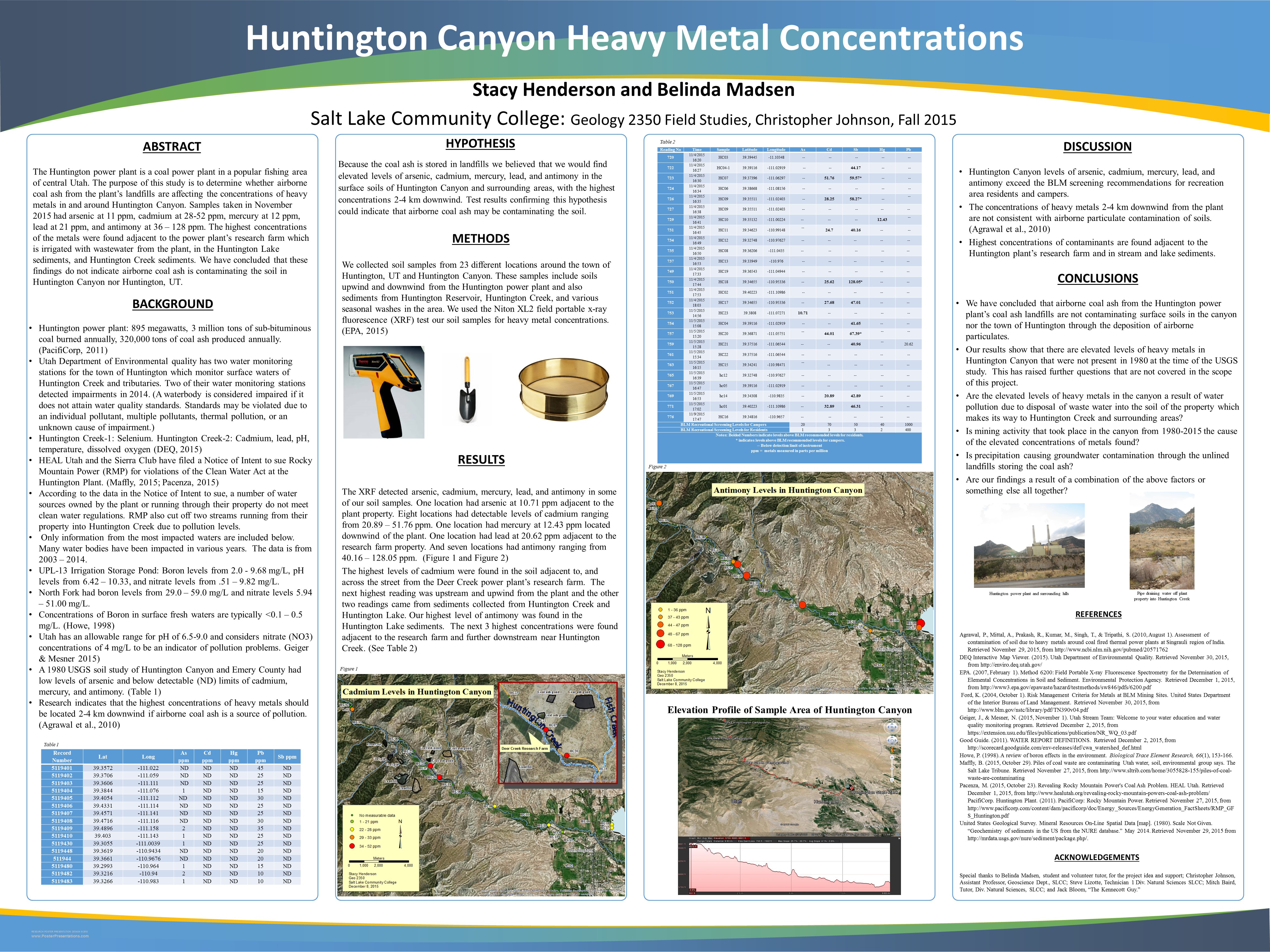
We collected soil samples from 23 different locations around the town of Huntington, UT and Huntington Canyon on November 3, 2015 over an 8 hour period from distances ranging from >1 km and up to 11 km from the plant itself. These samples include soils upwind and downwind from the Huntington power plant and also sediments from Huntington Reservoir, Huntington Creek, and various seasonal washes in the area. We used the EPA’s method 6200 in collecting and processing our soil samples. Four to five aliquots spaced 10 feet apart covering approximately 30-40 square feet were used in each sample at each location. We used a generic plastic food sifter in the field to homogenize the soil and remove any large pebbles. The soil was then bagged, labeled, and taken to the geology lab at Salt Lake Community College. Each sample soil that was wet was dried in a toaster oven in its own paper cupcake wrapper to avoid cross contamination. Once dried each aliquot was sifted to 0.0098” using a U.S.A. Standard Testing Sieve (A.S.T.M.E.-11 specification). We used the Niton XL2 field portable x-ray fluorescence (XRF) test our soil samples for heavy metal concentrations. (EPA, 2007)
Results
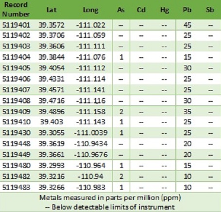
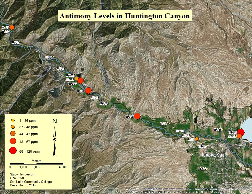
The XRF detected arsenic, cadmium, mercury, lead, and antimony in some of our soil samples. One location had arsenic at 10.71 ppm adjacent to the plant property. Eight locations had detectable levels of cadmium ranging from 20.89 – 51.76 ppm. One location had mercury at 12.43 ppm located downwind of the plant. One location had lead at 20.62 ppm adjacent to the research farm property. And seven locations had antimony ranging from 40.16 – 128.05 ppm. (Table 2)
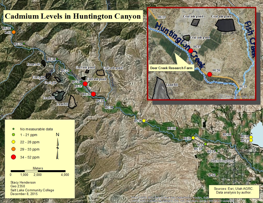
The highest levels of cadmium were found in the soil adjacent to, and across the street from the Deer Creek power plant’s research farm. The next highest reading was upstream and upwind from the plant and the other two readings came from sediments collected from Huntington Creek and Huntington Lake. Our highest level of antimony was found in the Huntington Lake sediments. The next three highest concentrations were found adjacent to the research farm and further downstream near Huntington Creek. (Figure 1 & Figure 2)
Discussion
According to OSHA cadmium exposure from the air cannot exceed .001 ppm during a worker’s 8 hour shift. It is unclear if there are ever plant employees on the research farm itself, and if so, how long they spend time working there, so although the concentrations near the research farm are elevated, we are unable to determine the impact this could have on employees at this time. (Figure 1)The BLM’s recreational screening levels for campers should not exceed 70 ppm and that number drops to 3 ppm for residents. This is a concern as the center of the town of Huntington is 14 km and is located downwind and downstream from the Huntington power plant (10-12 km from the research farm). More research would need to be done for the water and soil in Huntington to determine if our findings are impacting the town in any way. According to our data, the third highest cadmium concentration of 32.89 ppm was located near the Bear Creek Campground, and while elevated, is not above the 70 ppm screening level. Also note that cadmium was not found in the 1980 USGS screenings of the Huntington Canyon. (Ford, 2004; OSHA, 1993; USGS 1980)
The number of sites and the concentrations of antimony found in our November 2105 samples lead us to believe that the Huntington plant is releasing antimony into the soil. However, the concentrations are not consistent with wind deposits which would be highest 2-4 km from the plant. Our highest concentration 128 ppm is found in the Huntington Lake sediments and the next 3 highest concentrations are adjacent to the research farm and land containing 3 coal ash ponds 7 km downstream and downwind. (Figure 1 & Figure 2) A study done in 1992 by the Agency for Toxic Substances and Disease Registry, U.S. Public Health Service (ATSDR) tested soil at a hazardous waste sites for antimony. Of 1307 samples taken, 153 contained antimony. The mean level was 8 ppm and the maximum level was 330 ppm. According to the EPA antimony in soil is usually found in very low concentrations (<1 ppm). Of 23 samples taken during our study, 11 contained antimony and the mean of our data was 46.61 ppm and our maximum was 128.05 ppm. We found that we had antimony in the 44-47 ppm range near the Bear Creek campground which is located northwest and upwind and upstream from the power plant. These concentrations are just below the 50 ppm recommended by the BLM for recreational campers. (ASTDR, 1992; EPA, 2015; Ford, 2004)
Arsenic, mercury, and lead each had one location that contained detectible levels by the instrument. Given that no further locations had levels that were detectable we are unable to form any conclusions regarding why those locations tested positive for arsenic, mercury, and lead nor where those metal deposits may have originated. Based on the USGS’s study in 1980, there were no detectable levels of mercury in the soil at that time. What we found interesting however, was that the USGS did detect arsenic from 1-2 ppm in some locations, and all locations in the canyon had lead from 10-45 ppm. Why these levels are now lower after the plant being in operation for 35 years since the study is a question that would need to be answered. (USGS, 1980)
Conclusion
Based on our evidence and previous research our results show that the Huntington power plant’s coal ash landfills are not resulting in airborne particulates contaminating the soils in Huntington Canyon nor the town of Huntington. Are the elevated levels of heavy metals in the canyon a result of water pollution due to disposal of waste water into the soil of the property which makes its way to Huntington Creek and surrounding areas? Is mining activity that took place in the canyon from 1980-2015 the cause of the elevated concentrations of metals found? Is precipitation causing groundwater contamination through the unlined landfills storing the coal ash? Or, are our findings a result of a combination of the above factors or something else altogether? More research will need to be done to attempt to answer the questions which arose from this study and to determine the exact cause of heavy metal contamination in soils that are not a result of airborne coal ash.
References
Agrawal, P., Mittal, A., Prakash, R., Kumar, M., Singh, T., & Tripathi, S. (2010, August 1). Assessment of contamination of soil due to heavy metals around coal fired thermal power plants at Singrauli region of India. Retrieved November 29, 2015, from http://www.ncbi.nlm.nih.gov/pubmed/20571762
ASTDR. (1992, September 1). Toxicological Profile for Antimony and Compounds. Agency for Toxic Substances and Disease Registry. Retrieved November 29, 2015, from http://www.atsdr.cdc.gov/toxprofiles/tp23.pdf
DEQ. (2015). DEQ Interactive Map Viewer. Utah Department of Environmental Quality. Retrieved November 30, 2015, from http://enviro.deq.utah.gov/
Earth Justice. (2015). Utah and Coal Ash Disposal in Ponds and Landfills. Earth Justice. Retrieved November 27, 2015, from http://earthjustice.org/sites/default/files/library/references/ut-coal-ash-factsheet.pdf
EPA. (1993, September 1). Locating and Estimating Air Emissions from Sources of Cadmium and Cadmium Compounds. Environmental Protection Agency. Retrieved November 29, 2015, from http://www3.epa.gov/ttnchie1/le/cadmium.pdf
EPA. (2007, February 1). Method 6200: Field Portable X-ray Fluorescence Spectrometry for the Determination of Elemental Concentrations in Soil and Sediment. Environmental Protection Agency. Retrieved December 1, 2015, from http://www3.epa.gov/epawaste/hazard/testmethods/sw846/pdfs/6200.pdf
EPA. (2015, September 10). Antimony Compounds. Environmental Protection Agency. Retrieved November 29, 2015, from http://www3.epa.gov/airtoxics/hlthef/antimony.html
Ford, K. (2004, October 1). Risk Management Criteria for Metals at BLM Mining Sites. United States Department of the Interior Bureau of Land Management. Retrieved November 30, 2015, from http://www.blm.gov/nstc/library/pdf/TN390v04.pdf
Geiger, J., & Mesner, N. (2015, November 1). Utah Stream Team: Welcome to your water education and water quality monitoring program. Utah State University. Retrieved December 2, 2015, from https://extension.usu.edu/files/publications/publication/NR_WQ_03.pdf
Good Guide. (2011). Water Report Definitions. Good Guide. Retrieved December 2, 2015, from http://scorecard.goodguide.com/env-releases/def/cwa_watershed_def.html
Howe, P. (1998). A review of boron effects in the environment. Biological Trace Element Research, 66(1), 153-166.
Maffly, B. (2015, October 29). Piles of coal waste are contaminating Utah water, soil, environmental group says. The Salt Lake Tribune. Retrieved November 27, 2015, from http://www.sltrib.com/home/3055828-155/piles-of-coal-waste-are-contaminating
OSHA. (1993, April 23). Substance Safety Data Sheet - Cadmium. Occupational Safety and Health Administration. Retrieved December 5, 2015, from https://www.osha.gov/pls/oshaweb/owadisp.show_document?p_table=STANDARDS&p_id=10036
Pacenza, M. (2015, October 23). Revealing Rocky Mountain Power's Coal Ash Problem. HEAL Utah. Retrieved December 1, 2015, from http://www.healutah.org/revealing-rocky-mountain-powers-coal-ash-problem/
PacifiCorp. Huntington Plant. (2011). PacifiCorp: Rocky Mountain Power. Retrieved November 27, 2015, from http://www.pacificorp.com/content/dam/pacificorp/doc/Energy_Sources/EnergyGeneration_FactSheets/RMP_GFS_Huntington.pdf
USGS. (1980). Mineral Resources On-Line Spatial Data [map]. Scale Not Given. Geochemistry of sediments in the US from the NURE database. United States Geological Survey. Retrieved November 29, 2015, from http://mrdata.usgs.gov/nure/sediment/package.php/
Webster, R., Barth, J., & Dubuc, R. (2015, October 15). Notice of Intent to File Citizen Suit for Violations of the Clean Water Act and the Resource Conservation and Recovery Act at the Huntington Power Plant near Huntington, Utah. HEAL Utah. Retrieved December 5, 2015, from http://www.publicjustice.net/sites/default/files/20151014 v4 Huntington Notice Letter Figures Appendix Final.pdf